
June 19, 2024
Still waiting… Just one little obstacle holds up the start of construction on the new Greenfield Chapel: Warren County approval of an engineer’s report on how water run-off from the new building will be handled.
Greenfield actually does a great job of handling its abundant supply of water and has done so for decades. So now is a logical time to take a close look at the great blessing of Greenfield’s water.
Anyone who has ever spent even a little time exploring the sacred, peaceful environs of Greenfield has likely found that the silence, the serenity, the sounds of chirping birds, the flower gardens, and numerous meditation sites all feed the soul.
Then, there’s the water features—streams that amble through the woods, numerous bridges, two ponds, and even a waterfall. The trail around the ponds and over the dam is sheer delight.
In fact, some of the most recognizable features of the Greenfield Retreat property have to do with water. Ever wonder where all this water comes from? And where does it go?
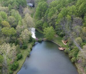
The largest bodies of water are the two ponds, which we call upper pond and lower pond. They’re separated by a dam with a waterfall at its center.
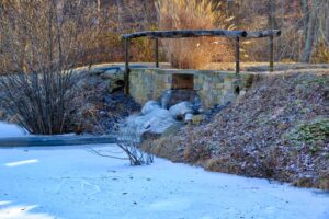
In winter, water under the dam freezes over
Ponds Created Just for Their Beauty
lt may come as a surprise to know that the ponds were actually created decades ago, back in the 1950s, by a previous Greenfield owner, just to make the property more beautiful. The story, which comes down from early SRF devotees living nearby, is that Margaret Owens longed to have ponds and a waterfall added to the gardens in front of the house. And her husband had workers divert a nearby stream to make that happen. (As you’re likely aware, devotee Margaret Owens left her magnificent Greenfield estate to Self-Realization Fellowship in 1981.)
The two ponds are fed by a perennial stream that originates at the far southeast end of the property. That stream, shown as a solid blue line on the U.S. Geological Survey (USGS) map below, is in turn fed by three intermittent streams, represented as blue-dashed lines, from even higher elevations on High Knob Mountain.
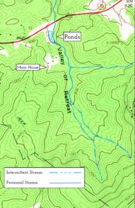
Although the perennial stream is not named on the USGS map, it is marked as “Dorsey’s Branch” on historical maps. Dr. H. Dorsey was one of the earliest pre-Civil War owners of Greenfield.
The two Greenfield ponds feature a flow-control dam. Water from Dorsey's Branch is diverted into the upper pond, and then returned to the main stream at the far end of the lower pond.
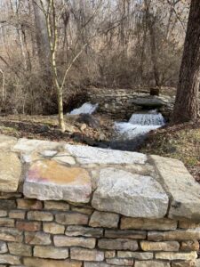
The water on the right side of the flow-control dam flows into the ponds, and water on the left into the main stream. The flow into the ponds can be adjusted by a hand-controlled gate.
Refrigeration, Before Electricity
Dorsey’s Branch was important to the early residents of Greenfield. Long before the current ponds were created, stream flow was diverted into a totally different pond, known as the “ice pond.” (Although the ice pond no longer exists, you can still see the dried up field where it was located.) Common practice in those days was to cut blocks of ice out of local ponds or lakes during the winter, and store them in an ice house or spring house, where they would stay frozen for most of the summer, providing essential refrigeration. (Ice cream, anyone?) The spring house behind the barn at Greenfield was probably used for this purpose.
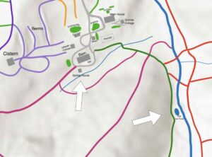
This map shows some of Greenfield’s trail network, gardens, and buildings. The arrows point to the location of the ice pond and the spring house.
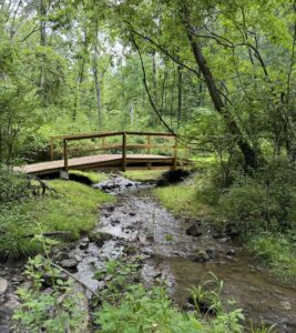
Not far from the site of the old ice pond, Dorsey’s Branch flows under one of the many Greenfield bridges.
From Greenfield to the Sea
Where does all the pond water go after it flows back into Dorsey’s Branch and leaves the Greenfield property? It flows through a culvert underneath John Marshall Highway, and continues for about 3/4 mile, where it slips into a larger stream, Manassas Run. Then after another 2 1/2 miles it flows into the Shenandoah River. After 40 more miles, the Shenandoah River joins with the Potomac River at Harper’s Ferry, West Virginia, and then meanders past Washington DC and into the Chesapeake Bay.
From Greenfield to the Bay, our water makes a journey of about 200 miles. Thus, our little drop of Greenfield water merges into the vast ocean.
Here, for your enjoyment, is a video drone trip around the Greenfield ponds. Even if you’ve walked the trails a number of times, a fly-over puts a whole new perspective on things. (Just click on the link.)